Showing posts with label Building simulation. Show all posts

Friday, May 18, 2018

Using Artificial Intelligence to Design Energy-Efficient Buildings

The National Science Foundation issued a statement on May 10, 2018 in which the agency envisions that "The effects of AI will be profound. To stay competitive, all companies will, to some extent, have to become AI companies. We are striving to create AI that works for them, and for all Americans." This is probably the strongest message and the clearest matching order from a top science agency in the world about a particular area of research thus far. The application of AI to the field of design, and more broadly, creativity, is considered by many as the moonshot of the ongoing AI revolution, which is why I have chosen to dedicate a considerable portion of my time and effort to this strategically important area.

I have added two more application categories of using genetic algorithms (GAs) to assist engineering design in Energy3D, the main platform based on which I am striving to create a "designerly brain." One example is to find the optimal position to add a new building with glass curtain walls to an open space in an existing urban block so that the new building would use the least amount of energy. The other example is to find the optimal sizes of the windows on different sides of a building so that the building would use the least amount of energy. To give you a quick idea about how GAs work in these cases, I recorded the following two screencast videos from Energy3D. To speed up the search processes visualized in the videos, I chose the daily energy use as the objective function and only optimized for the winter condition. The solutions optimized for the annual energy use are shown later in this article.


Figure 1: A location of the building recommended by GA if it is in Boston.
Figure 2: A location of the building recommended by GA if it is in Phoenix.
For the first example, the energy use of a building in an urban block depends on how much solar energy it receives. In the winter, solar energy is good for the building as it warms up the building and saves the heating energy. In the summer, excessive heating caused by solar energy must be removed through air conditioning, increasing the energy use. The exact amount of energy use per year depends on a lot of other factors such as the fenestration of the building, its insulation, and its size. In this demo, we only focus on searching a good location for a building with everything else fixed. I chose a population with 32 individuals and let GA run for only five generations. Figures 1 and 2 show the final solutions for Boston (a heating-dominant area) and Phoenix (a cooling-dominant area), respectively. Not surprisingly, the GA results suggest that the new building be placed in a location that has more solar access for the Boston case and in location that has less solar access for the Phoenix case.

Figure 3: Window sizes of a building recommended by GA for Chicago.
Figure 4: Window sizes of a building recommended by GA for Phoenix.
For the second example, the energy use of a building depends on how much solar energy it receives through the windows and how much thermal energy transfers through the windows (since windows typically have less thermal resistance than walls). In the winter, while a larger window allows more solar energy to shine into the building and warm it up during the day, it also allows more thermal energy to escape through the larger area, especially at night. In the summer, both solar radiation and heat transfer through a larger window will contribute to the increase of the energy needed to cool the building. And this complicated relationship changes when the solution is designed for a different climate. Figures 3 and 4 show the final solutions for Chicago and Phoenix as suggested by the GA results, respectively. Note that not all GA results are acceptable solutions, but they can play advisory roles during a design process, especially for novice designers who do not have anyone to consult with.

In conclusion, artificial intelligence such as GA provides automated procedures that can help designers find optimal solutions more efficiently and thereby free them up from tedious, repetitive tasks if an exhaustive search of the solution space is necessary. Energy3D provides an accessible platform that integrates design, visualization, and simulation seamlessly to demonstrate these potential and capabilities. Our next step is to figure out how to translate this power into instructional intelligence that can help students and designers develop their abilities of creative thinking.

Wednesday, August 16, 2017

Canadian researchers use Energy3D to design renewable energy systems for mobile hospitals in Libya

Fig. 1: A H-shaped mobile hospital designed using Energy3D
Prof. Tariq Iqbal and his student Emadeddin Hussein from the Department of Electrical and Computer Engineering at the Memorial University of Newfoundland in Canada published a paper in the Journal of Clean Energy Technologies titled with "Design of Renewable Energy System for a Mobile Hospital in Libya."

The researchers recognized that the United Nations' efforts to provide field hospitals have recently decreased in areas that face a high risk in transportation, lack of power, and lack of security for field officers, such as war-torn countries like Libya and Syria. In those unfortunate parts of the world, lack of aids and health resources have a major effect on people's lives. Their paper proposes a photovoltaics (PV) hybrid system for supplying an electric load of a mobile hospital in an area where there is no grid. Such a hybrid system is believed to be a cost-effective solution to power a mobile hospital capable of providing uninterrupted power to support a doctor and two nurses.

Our Energy3D software was used in their research as a simulation tool to study the heat load and optimize the design solution. Figure 1 shows a H-shaped design from their paper (I guess the H-shape was chosen because it is the initial of the word "hospital").

Fig. 2: Energy3D supports 450 regions from 117 countries.
We highly appreciate the researchers' efforts in finding ways to help people living in remote areas and war zones in the world. We are glad to learn that our software may have helped a bit in providing humanitarian aids to those people. Inspired by their work, we will add more weather data to Energy3D to cover areas in the state of unrest (455 regions from 120 countries are currently supported in Energy3D, as shown in Figure 2). In the future, we will also develop curriculum materials and design challenges to engage students all over the world to join these humanitarian efforts through our global drive and outreach.

Friday, August 4, 2017

Polish researchers independently validated Energy3D with Building Energy Simulation Test (BESTEST)

Fig. 1: BESTEST600 test case
Fig. 2: Comparison of Energy3D results with those of other simulation tools
The Building Energy Simulation Test (BESTEST) is a test developed by the International Energy Agency for evaluating various building energy simulation tools, such as EnergyPlus, BLAST, DOE2, COMFIE, ESP-r, SERIRES, S3PAS, TASE, HOT2000, and TRNSYS. The methodology is based on a combination of empirical validation, analytical verification, and comparative analysis techniques. A method was developed to systematically test whole building energy simulation programs. Geometrically simple cases, such as cases BESTEST600 to 650, are used to test the ability of a subject program to model effects such as thermal mass, direct solar gain windows, shading devices, infiltration, internal heat gain, sunspaces, earth coupling, and setback thermostat control. The BESTEST procedure has been used by most building simulation software developers as part of their standard quality control program. More information about BESTEST can be found at the U.S. Department of Energy's website.

Prof. Dr. Robert Gajewski, Head of Division of Computing in Civil Engineering, Faculty of Civil Engineering, Warsaw University of Technology, and his student Paweł Pieniążek recently used BESTEST600-630 test case (Figure 1) to evaluate the quality of Energy3D's predictions of heating and cooling costs of buildings. By comparing Energy3D's results with those from major building energy simulation tools (Figure 2), they concluded that, "[Energy3D] proved to be an excellent tool for qualitative and quantitative analysis of buildings. Such a program can be an excellent part of a computer supported design environment which takes into account also energy considerations."

Their paper was published here.

Thursday, July 6, 2017

Energy3D turns the globe into a powerful engineering design lab for everyone

Fig. 1: Dots represent regions supported in Energy3D.
Many of the readers of my blog may not know Energy3D is, in fact, also a Google Maps application. Energy3D allows users to import a satellite image of a site through the Google Maps API as the "ground image" in its 3D coordinate system, on top of which users can draw 3D structures such as buildings or power plants. Built-in simulation engines can then be used to test and analyze these structures without having to switch to another tool and leave the scene (something known as "concurrent analysis" in the CAD industry). These engines use large geographical and weather datasets for the site as inputs for simulations to accurately take environmental factors such as air temperature and solar radiation into account. As the climate is probably the single most important factor that drives the energy usage in buildings where we live and work, it is important to use weather data from a typical meteorological year (TMY) in a simulation. If no weather data is available for the site, Energy3D will automatically select the nearest location from a network of more than 525 supported worldwide regions (Figure 1) when you import the satellite image from Google Maps. The following table lists the numbers of regions in 176 countries that are currently supported in Energy3D. The United States is covered by a network of 164 nodes. So if you are in the United States, you will have a better chance to find a location that may represent the climate of your area.

Afghanistan 1 Albania 1 Algeria 6
Angola 1 Argentina 3 Armenia 1
Australia 11 Austria 1 Azerbaijan 1
Bahamas 1 Bahrain 1 Bangladesh 1
Belarus 1 Belgium 1 Belize 1
Bolivia 1 Bosnia & Herzegovina 1 Botswana 1
Brazil 8 Brunei 1 Bulgaria 1
Burkina Faso 1 Burundi 1 Cambodia 1
Cameroon 1 Canada 10 Cape Verde 1
Central African Republic 1 Chad 1 Chile 12
China 42 Colombia 2 Comoros 1
Congo 1 Costa Rica 1 Croatia 1
Cuba 1 Cyprus 2 Czech 1
DR Congo 1 Denmark 1 Djibouti 1
Dominica 1 Dominican Republic 1 East Timor 1
Ecuador 1 Egypt 1 El Salvador 1
Equatorial Guinea 1 Eritrea 1 Estonia 1
Ethiopia 1 Fiji 2 Finland 1
France 8 Gabon 1 Gambia 1
Georgia 1 Germany 12 Ghana 1
Greece 2 Guatemala 1 Guinea 1
Guinea-Bissau 1 Guyana 1 Haiti 1
Honduras 1 Hungary 1 Iceland 1
India 11 Indonesia 4 Iran 3
Iraq 1 Ireland 1 Israel 1
Italy 5 Ivory Coast 1 Jamaica 1
Japan 6 Jerusalem 1 Jordan 1
Kazakhstan 1 Kenya 1 Kosovo 1
Kuwait 1 Kyrgyzstan 1 Laos 1
Latvia 1 Lebanon 1 Lesotho 1
Liberia 1 Libya 2 Liechtenstein 1
Lithuania 1 Luxembourg 1 Macedonia 1
Madagascar 1 Malawi 1 Malaysia 2
Maldives 1 Mali 1 Malta 1
Marshall Islands 1 Mauritania 1 Mauritius 1
Mexico 4 Moldova 1 Monaco 1
Mongolia 1 Montenegro 1 Morocco 3
Mozambique 1 Myanmar 2 Namibia 1
Nepal 1 Netherlands 1 New Zealand 2
Nicaragua 1 Niger 1 Nigeria 1
North Korea 1 Norway 1 Oman 1
Pakistan 4 Panama 1 Papua New Guinea 1
Paraguay 1 Peru 2 Philippines 1
Poland 7 Portugal 2 Qatar 1
Republic of China 2 Romania 1 Russia 7
Rwanda 1 Saudi Arabia 2 Senegal 1
Serbia 2 Sierra Leone 1 Singapore 1
Slovakia 1 Slovenia 1 Solomon Islands 1
Somalia 1 South Africa 8 South Korea 2
South Pole 1 South Sudan 1 Spain 8
Sri Lanka 1 Sudan 1 Sweden 1
Switzerland 3 Syria 2 Tajikistan 1
Tanzania 2 Thailand 2 Togo 1
Trinidad & Tobago 1 Tunisia 1 Turkey 3
Turkmenistan 1 Uganda 1 Ukraine 2
United Arab Emirates 2 United Kingdom 6 United States 164
Uruguay 1 Uzbekistan 1 Venezuela 1
Vietnam 2 Western Sahara 1 Yemen 1
Zambia 1 Zimbabwe 1

Fig. 2: Solar sites in Fitchburg, MA.
Energy3D's capability of turning Google Maps into a gigantic virtual engineering design lab has tremendous potential in STEM education and energy revolution. It allows students to pick and choose sites for designing renewable energy and energy efficiency solutions that are most relevant to their lives, such as their home and school buildings (Figure 2). It gives students an authentic tool that supports them to scientifically investigate all sorts of possibilities to design a more sustainable world and effectively communicate their ideas to the public. And, most importantly, with Energy3D being a free tool that anyone can use at zero cost, this can happen at the global scale to engage every student in the world to act now and make a difference!

This global vision is not new. Back in 1995, the National Science Foundation funded my colleagues Boris Berenfeld, Bob Tinker, and Dan Barstow, who were at TERC at that time, a grant to develop a curriculum that they touted as the Globe Lab. The Global Lab Curriculum meant to provide an interdisciplinary, one-year course at the secondary level that supports science standards and school reform through intercultural, scientifically meaningful, and collaborative student investigations in environmental studies. Students were given the opportunity to experience all aspects of genuine scientific research: problem identification, background study, project design, collaboration, data analysis, and communication.

Fig. 3: Solar power plants around the world.
More than 20 years later, technology has advanced so much that we now have many more resources and tools to rethink about this idea. With Google Maps and weather data for countless regions in the world, Energy3D is poised to become a true example of Globe Lab for science and engineering. The integration of the software and our Solarize Your World Curriculum with the current, unstoppable waves of renewable energy innovation and movement worldwide will create numerous exciting possibilities for youth to become truly involved and engaged in shaping their world and their future (Figure 3). While we undertake this grand challenge, it is utterly important to keep in mind that renewable energy does not just stand for some kind of green ideology related only to potential tax hikes -- it also represents trillions of dollars worth of business opportunities and investment in the coming decades committed by almost all governments on the planet to revamp the world's energy infrastructure to provide cleaner air and healthier environment for their citizens. Given this level of global significance, our work will only become more essential and the implications will only become more profound.

As we are mourning the loss of Bob Tinker, one of the architects of the Global Lab Curriculum, carrying on this line of work will be the best way to remember his visions, honor his contributions, and celebrate his life.

Thursday, January 5, 2017

Designing on lot maps in Energy3D

Energy3D allows users to import an Earth View image from Google Maps and then design 3D structures on top of it. The image provides the reference frame, boundary lines, and other visual aids for getting the geometry right. What if there is no Google Map image, or the Google Map image is outdated, or you simply want to draw on a different substrate other than a Google Map image?

Bob Loy, a teacher at Creekside Middle School in Carmel, Indiana, has such a situation. His school is working with a builder to engage young students to design new constructions in their areas. His goal is for them to design houses that fit on assigned lots planned by the builder and then make them as energy-efficient as possible by applying all sorts of solutions, including insulation, passive solar strategies, and solar panel technologies.

Upon his request, I have added a new feature to Energy3D (V6.2.7) to enable users to import an image from a file to serve as the ground for designing a building, a solar farm, or anything made possible by Energy3D.

Since users can import any image that represents any size in the real world, it is their responsibilities to make sure that the dimension and orientation of the image that appears as the ground in an Energy3D model is accurate. Setting the correct dimension can be done by rescaling the image after it has been imported. There are some other requirements of such images, though. For instance, they have to be a square image (its width and height must be the same) with a reasonably high resolution (otherwise they will appear to be too blurry to look once they are transformed into 3D textures). Users must know the scale of such an image, i.e., the exact length in the real world that a unit length in the image represents. Once the image is inside Energy3D, users should measure its width or height within Energy3D and then rescale the image to make sure that the measurement matches the value in the real world. Currently one can use a foundation object in Energy3D as a ruler, but a real ruler should and will be added in a future version to measure any distance in a more intuitive manner.

Friday, July 1, 2016

Comparing Energy3D's prediction of solar panel yields with real data from a house in Massachusetts

Fig. 1: Street view before solar panel installation
How accurately can Energy3D predict the energy generated by solar panels? This is critical for Energy3D as our goal is to provide a reliable engineering tool for modeling and designing solar energy applications. Even if our primary target users are students, there is no room for complacency, simply because engineering is all about accuracy and it is important that we pass this spirit to the next generation.

Fig. 2: Comparing predicted and real data
We have compared Energy3D's results with sensors placed on the horizontal plane and the vertical south-facing plane and concluded that Energy3D predicts satisfactory results. But we haven't compared Energy3D's predictions with output data from real solar panels.

My colleague Dan Damelin of the Concord Consortium has recently had solar panels installed for his house (Figure 1 shows his house before solar panels were installed). His solar system, which consists of 34 SunPower panels estimated to have a total power output of 11 kW, went into operation last December. By the time I am writing this blog post, he has accumulated six months of data, providing a good basis for a case study. So I asked our summer intern, Guanhua Chen, a PhD student from the University of Miami, to conduct a case study that uses Energy3D to analyze Dan's solar system.

The solar company that Dan hired came to his house, surveyed the site, and gave him a proposal that detailed the layout of the 34 panels. They also provided him a projection of monthly outputs, juxtaposed with his monthly electricity bill. The solar company's estimate is shown in Figure 2 as the gray line, whereas the bar graph represents the monthly electricity usages.

Fig. 3: An Energy3D model of the house
Guanhua used Energy3D to create a 3D model of the house and put 34 SunPower panels following the actual layout done by the solar installer (Figure 3). The dimension of the SunPower panels is slightly different from that of most other brands (which is approximately 3 by 5 feet). They have great solar cell efficiency, which is about 21% -- one of the highest in the market.

Comparing with the real production data from December to June (represented by the red line in Figure 2), the solar company's projection overestimates a bit of the yields in the winter months but significantly underestimates those in the summer months. By comparison, Energy3D's predictions (represented by the green line) for the spring and summer months agree much better with the real data. Like the solar company's predictions, Energy3D seems to overestimate the winter production. This may be due to the fact that we haven't incorporated the effect of snow and ice in the simulation core of Energy3D. Should we factor this effect in the calculation, the results would be more accurate. In our next iteration of the computational core, we will build a mathematical model of the snow effect.

If Energy3D can outperform the production software used by the solar installer in this case -- as Figure 2 seems to suggest, the implication could be enormous, because this is a free tool so easy that every student can use. With it, we now have a serious chance to engage and enable students to solve critical energy problems. And there are million of students out there! If a fraction of them can be turned into little solar engineers by Energy3D,  the world could be a better place sooner.

Wednesday, May 18, 2016

Energy3D makes designing realistic buildings easy

The annual yield and cost benefit analyses of rooftop solar panels based on sound scientific and engineering principles are critical steps to the financial success of building solarization. Google's Project Sunroof provides a way for millions of property owners to get recommendations for the right solar solutions.


Another way to conduct accurate scientific analysis of solar panel outputs based on their layout on the rooftop is to use a computer-aided engineering (CAE) tool to do a three-dimensional, full-year analysis based on ab initio scientific simulation. Under the support of the National Science Foundation since 2010, we have been developing Energy3D, a piece of CAE software that has the goal of bringing the power of sophisticated scientific and engineering simulations to children and laypersons. To achieve this goal, a key step is to support users to rapidly sketch up their own buildings and the surrounding objects that may affect their solar potentials. We feel that most CAD tools out there are probably too difficult for average users to create realistic models of their own houses. This forces us to invent new solutions.

We have recently added countless new features to Energy3D to progress towards this goal. The latest version allows many common architectural styles found in most parts of the US to be created and their solar potential to be studied. The screenshots embedded in this article demonstrate this capability. With the current version, each of these designs took myself approximately an hour to create from scratch. But we will continue to push the limit.

The 3D construction user interface has been developed based on the tenet of supporting users to create any structure using a minimum set of building blocks and operations. Once users master a relatively small set of rules, they are empowered to create almost any shape of building as they wish.

Solar yield analysis of the first house
The actual time-consuming part is to get the right dimension and orientation of a real building and the surrounding tall objects such as trees.
Google's 3D map may provide a way to extract these data. Once the approximate geometry of a building is determined, users can easily put solar panels anywhere on the roof to check out their energy yield. They can then try as many different layouts as they wish to compare the yields and select an optimal layout. This is especially important for buildings that may have partial shades and sub-optimal orientations. CAE tools such as Energy3D can be used to do spatial and temporal analysis and report daily outputs of each panel in the array, allowing users to obtain fine-grained, detailed results and thus providing a good simulation of solar panels in day-to-day operation.

The engineering principles behind this solar design, assessment, and optimization process based on science is exactly what the Next Generation Science Standards require K-12 students in the US to learn and practice. So why not ask children for help to solarize their own homes, schools, and communities, at least virtually? The time for doing this can never be better. And we have paved the road for this vision by creating one of easiest 3D interfaces with compelling scientific visualizations that can potentially entice and engage a lot of students. It is time for us to test the idea.

To see more designs, visit this page.

Sunday, January 31, 2016

Programmable thermostats allow Energy3D to study the effects of human behavior on home energy use

Figure 1
Energy3D Version 5.1 has incorporated a new feature: programmable thermostats (Figure 1). This allows users to add a programmable thermostat to each building in the design. Such a thermostat allows building researchers to model the occupants' schedules and thermal comfort preferences, making it possible to include a human dimension into building simulation.

Figure 2
Figure 2 shows the hourly heating cost of a house on January 1st when the thermostat temperature is set to be 18, 19, 20, 21, and 22 °C. Obviously, the higher temperature you set, the higher the cost will be. Notice, however, that the hourly heating cost might be close to zero around noon because the solar energy alone might be enough to provide the heating (it depends on the size of the house, the size of the windows, and the locations of the windows).

Figure3
The thermostat has a graphical user interface that can be used to set the temperature of a building by hour, week, and month (Figure 3). This flexible user interface can adjust the temperature of a thermostat in four different ways:
  • Drag "All" button up or down to increase or decrease the temperatures in all the hours of all the days in a week of the selected month. 
  • Drag the hour button up or down to increase or decrease the temperatures in the selected hour of all the days in a week of the selected month.
  • Drag a gray temperature button on the right up or down to increase or decrease the temperatures in all the hours of the selected day;
  • Drag any temperature button up or down to increase or decrease the temperature in the selected hour of the selected day.
In the future, we plan to extend this feature so that Energy3D can model "smart" thermostats such as the Nest Learning Thermostat, which can adapt to the occupants' specific needs and schedules.

Sunday, November 8, 2015

Solarizing a house in Energy3D

Fig. 1 3D model of a real house near Boston (2,150 sq ft).
On August 3, 2015, President Obama announced the Clean Power Plan – a landmark step in reducing carbon pollution from power plants that takes real action on climate change. Producing clean energy from rooftop solar panels can greatly mitigate the problems in current power generation. In the US, there are more than 130 million homes. These homes, along with commercial buildings, consume more than 40% of the total energy of the country. With improving generation and storage technologies, a large portion of that usage could be generated by home buildings themselves.

A practical question is: How do we estimate the energy that a house can potentially generate if we put solar panels on top of it? This estimate is key to convincing homeowners to install solar panels or the bank to finance it. You wouldn't buy something without knowing its exact benefits, would you? This is why solar analysis and evaluation are so important to the solar energy industry.

The problem is: Every building is different! The location, the orientation, the landscape, the shape, the roof pitch, and so on, vary from one building to another. And there are over 100 MILLION of them around the country! To make the matter even more complicated, we are talking about annual gains, which require the solar analyst to consider solar radiation and landscape changes in four seasons. With all these complexities, no one can really design the layout of solar panels and calculate their outputs without using a 3D simulation tool.

There may be solar design and prediction software from companies like Autodesk. But for three reasons, we believe that our Energy3D CAD software will be a relevant tool in this marketplace. First, our goal is to enable everyone to use Energy3D without having to go through the level of training that most engineers must go through with other CAD tools in order to master them. Second, Energy3D is completely free of charge to everyone. Third, the accuracy of Energy3D's solar analysis is comparable with that of others (and is improving as we speak!).

With these advantages, it is now possible for homeowners to evaluate the solar potential of their houses INDEPENDENTLY, using an incredibly powerful scientific simulation tool that has been designed for the layperson.

In this post, I will walk you through the solar design process in Energy3D step by step.

1) Sketch up a 3D model of your house

Energy3D has an easy-to-use interface for quickly constructing your house in a 3D environment. With this interface, you can create an approximate 3D model of your house without having to worry about details such as interiors that are not important to solar analysis. Improvements of this user interface are on the way. For example, we just added a handy feature that allows users to copy and paste in 3D space. This new feature can be used to quickly create an array of solar panels by simply copying a panel and hitting Ctrl/Command+V a few times. As trees are important to the performance of your solar panels, you should also model the surrounding trees by adding various tree objects in Energy3D. Figure 1 shows a 3D model of a real house in Massachusetts, surrounded by trees. Notice that this house has a T shape and its longest side faces southeast, which means that other sides of its roof may worth checking.
Fig. 2 Daily solar radiation in four seasons

2) Examine the solar radiation on the roof in four seasons

Once you have a 3D model of your house and the surrounding trees, you should take a look at the solar radiation on the roof throughout the year. To do this, you have to change the date and run a solar simulation for each date. For example, Figure 2 shows the solar radiation heat maps of the Massachusetts house on 1/1, 4/1, 7/1, and 10/1, respectively. Note that the trees do not have leaves from the beginning of December to the end of April (approximately), meaning that their impacts to the performance of the solar panels are minimal in the winter.

The conventional wisdom is that the south-facing side of the roof is a good place to put solar panels. But very few houses face exact south. This is why we need a simulation tool to analyze real situations. By looking at the color maps in Figure 2, we can quickly figure out that the southeast-facing side of the roof of this house is the optimal side for solar panels and we also know that the lower part of this side is shadowed significantly by the surrounding trees.

Fig. 3 Solarizing the house
3) Add, copy, and paste solar panels to create arrays

Having decided which side to lay the solar panels, the next step is to add them to it. You can drop them one by one. Or drop the first one near an edge and then copy and paste it to easily create an array. Repeat this for three rows as illustrated in Figure 3. Note that I chose the solar panels that have a light-electricity conversion efficiency of 15%, which is about average in the current market. New panels may come with higher efficiency.

The three rows have a total number of 45 solar panels (3 x 5 feet each). From Figure 2, it also seems the T-wing roof leaning towards west may be a sub-optimal place to go solar. Let's also put a 2x5 array of panels on that side. If the simulation shows that they do not worth the money, we can just delete them from the model. This is the power of the simulation -- you do not have to pay a penny for anything you do with a virtual house (and you do not have to wait for a year to evaluate the effect of anything you do on its yearly energy usage).

4) Run annual energy analysis for the building

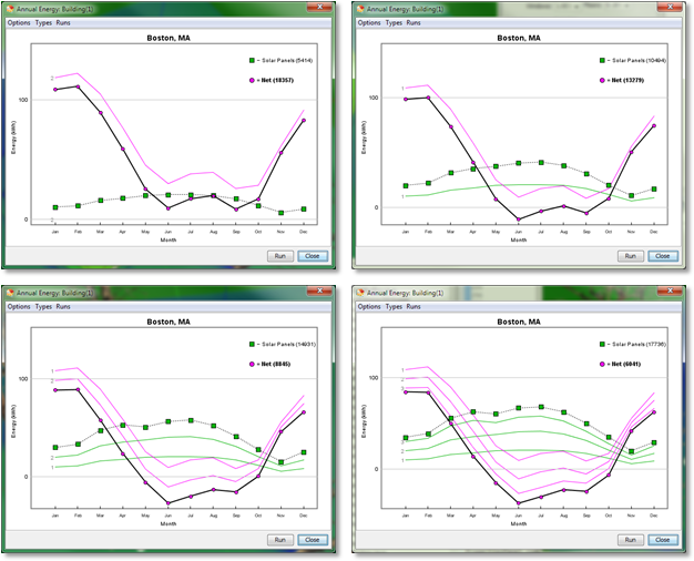
Fig. 4 Energy graphs with added solar panels
Now that we have put up the solar panels, we want to know how much energy they can produce. In Energy3D, this is as simple as selecting "Run Annual Energy Analysis for Building..." under the Analysis Menu. A graph will display the progress while Energy3D automatically performs a 12-month simulation and updates the results (Figure 4).

I recommend that you run this analysis every time you add a row of solar panels to keep track of the gains from each additional row. For example, Figure 4 shows the changes of solar outputs each time we add a row (the last one is the 10 panels added to the west-facing side of the T-wing roof). The following lists the annual results:
  • Row 1, 15 panels, output: 5,414 kWh --- 361 kWh/panel
  • Row 2, 15 panels, output: 5,018 kWh (total: 10,494 kWh) --- 335 kWh/panel
  • Row 3, 15 panels, output: 4,437 kWh (total: 14,931 kWh) --- 296 kWh/panel
  • T-wing 2x5 array, 10 panels, output: 2,805 kWh (total: 17,736 kWh) --- 281 kWh/panel
These results suggest that 30 panels in Rows 1 and 2 are probably a good solution for this house -- they generate a total of 10,494 kWh in a year. But if we have better (i.e., high efficiency) and cheaper solar panels in the future, adding panels to Row 3 and the T-wing may not be such a bad idea.

Fig. 5 Comparing solar panels at different positions
5) Compare the solar gains of panels at different positions

In addition to analyze the energy performance of the entire house, Energy3D also allows you to select individual elements and compare their performances. Figure 5 shows the comparison of four solar panels at different positions. The graph shows that the middle positions in Row 3 are not good spots for solar panels. Based on this information, we can go back to remove those solar panels and redo the analysis to see if we will have a better average output of Row 3.

After removing the five solar panels in the middle of Row 3, the total output drops to 16,335 kWh, meaning that the five panels on average output 280 kWh each.

6) Decide which positions are acceptable for installing solar panels

The analysis results thus far should provide you enough information with regard to whether it worth your money to solarize this house and, if yes, how to solarize it. The real decision depends on the cost of electricity in your area, your budget, and your expectation of the return of investment. With the price of solar panel continuing to drop, the quality continues to improve, and the pressure to reduce fossil energy usage continues to increase, building solarization is becoming more and more viable.

Solar analysis using computational tools is typically considered as the job of a professional engineer as it involves complicated computer-based design and analysis. The high cost of a professional engineer makes analyzing and evaluating millions of buildings economically unfavorable. But Energy3D reduces this task to something that even children can do. This could lead to a paradigm shift in the solar industry that will fundamentally change the way residential and commercial solar evaluation is conducted. We are very excited about this prospect and are eager to with the energy industry to ignite this revolution.

Monday, October 12, 2015

Daily energy analysis in Energy3D

Fig. 1: The analyzed house.
Energy3D already provides a set of powerful analysis tools that users can use to analyze the annual energy performance of their designs. For experts, the annual analysis tools are convenient as they can quickly evaluate their designs based on the results. For novices who are trying to understand how the energy graphs are calculated (or skeptics who are not sure whether they should trust the results), the annual analysis is sometimes a bit like a black box. This is because if there are too many variables (which, in this case, are seasonal changes of solar radiation and weather) to deal with at once, we will be overwhelmed. The total energy data are the results of two astronomic cycles: the daily cycle (caused by the spin of the Earth itself) and the annual cycle (caused by the rotation of the Earth around the Sun). This is why novices have a hard time reasoning with the results.

Fig. 2: Daily light sensor data in four seasons.
To help users reduce one layer of complexity and make sense of the energy data calculated in Energy3D simulations, a new class of daily analysis tools has been added to Energy3D. These tools allow users to pick a day to do the energy analyses, limiting the graphs to the daily cycle.

For example, we can place three sensors on the east, south, and west sides of the house shown in Figure 1. Then we can pick four days -- January 1st, April 1st, July 1st, and October 1st -- to represent the four seasons. Then we run a simulation for each day to collect the corresponding sensor data. The results are shown in Figure 2. These show that in the winter, the south-facing side receives the highest intensity of solar radiation, compared with the east and west-facing sides. In the summer, however, it is the east and west-facing sides that receive the highest intensity of solar radiation. In the spring and fall, the peak intensities of the three sides are comparable but they peak at different times.

Fig. 3: Daily energy use and production in four seasons.
If you take a more careful look at Figure 2, you will notice that, while the radiation intensity on the south-facing side always peaks at noon, those on the east and west-facing sides generally go through a seasonal shift. In the summer, the peak of radiation intensity occurs around 8 am on the east-facing side and around 4 pm on the west-facing side, respectively. In the winter, these peaks occur around 9 am and 2 pm, respectively. This difference is due to the shorter day in the winter and the lower position of the Sun in the sky.

Energy3D also provides a heliodon to visualize the solar path on any given day, which you can use to examine the angle of the sun and the length of the day. If you want to visually evaluate solar radiation on a site, it is best to combine the sensor and the heliodon.

You can also analyze the daily energy use and production. Figure 3 shows the results. Since this house has a lot of south-facing windows that have a Solar Heat Gain Coefficient of 80%, the solar energy is actually enough to keep the house warm (you may notice that your heater runs less frequently in the middle of a sunny winter day if you have a large south-facing window). But the downside is that it also requires a lot of energy to cool the house in the summer. Also note the interesting energy pattern for July 1st -- there are two smaller peaks of solar radiation in the morning and afternoon. Why? I will leave that answer to you.